

Seeing the Forest for the Tech
Header image by Interpine Innovation
Advances in tech seem to happen so rapidly it can be hard to keep up. Super-efficient heavy machinery, digital applications, remote sensing & mapping tools, and drone technology ― not to mention advances in our understanding of forests as interconnected ecological systems ― have changed the way we manage forests.
Below we discuss three technologies increasingly being used in forestry: GIS, lidar, and drones. GIS is used by most forestry operations and by many small forest landowners. Drones are an increasingly popular tool for documenting forest management. Lidar, while not quite an “emerging” technology anymore, has yet to be totally accessible and available forest landowners at the individual level but is increasingly used in large-scale forest management.
GIS
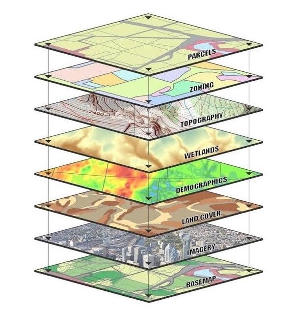
A Geographic Information System (GIS) is a digital framework that’s used to analyze and display data tied to a location. Applications of GIS run the gamut, from tracking whale movements around Hawaii to mapping Sasquatch sightings in Washington to putting the world’s most vulnerable people on the map. At its simplest, GIS can be used to create a visually pleasing map. But more often GIS is used in sophisticated analyses that help people answer questions and make decisions.
In forestry GIS is used to write forest management plans, conduct forest inventories, plan harvests, find and track insect and disease threats, map wildfire severity, and much more.
NNRG’s Lead Forester Jaal Mann has been using GIS in his work for years. He remembers when, in his previous position as a forester, the company switched from hand-drawn paper maps to GIS maps. “It made a huge difference in how they thought about their forests.”
“To be able to create maps of important areas, create stream buffers, and measure distances on a custom map are really game-changers, and give you a perspective of a forest that you’d never get on the ground.”
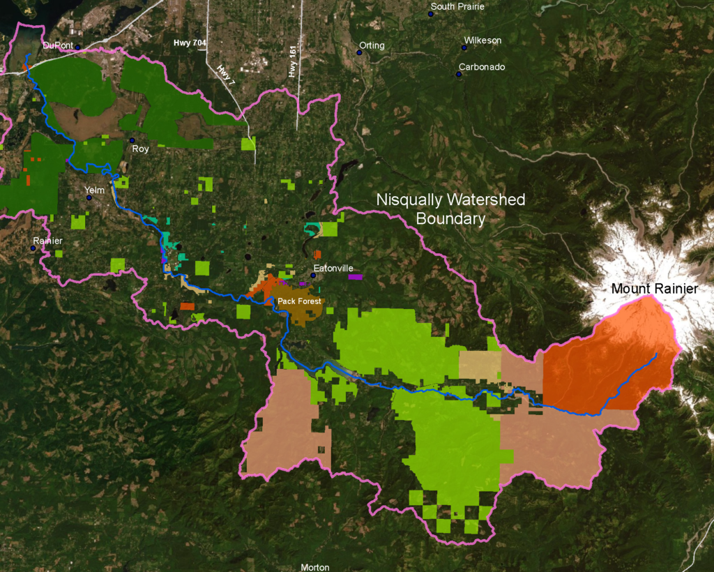
Jaal used GIS to create the map below, which shows how forestlands in the Nisqually watershed are managed. 84% of the watershed is forested — and 50% of that forestland is managed to a higher standard than Washington State’s forest practices. Go Nisqually watershed forest owners!
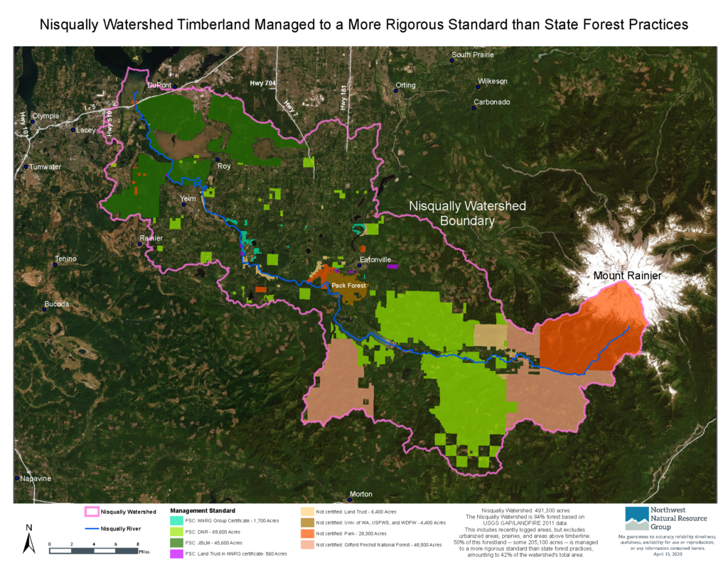
For a map like the Nisqually map, “the trickiest part is figuring out what information to include and what to leave out,” says Jaal. “It’s really easy to make a cluttered map that has a huge amount of information but is pretty much useless. We went through quite a few drafts of this map, considering who the audience is and what information they really need to be able to get from it. In creating maps like this one, there is probably more graphic design involved than actual GIS analysis.”
GIS Resources
- Inventory and Mapping: Basic Inventory and Digital Mapping of Nontimber Forest Products on Small Private Forestlands – A guide for beginners from the Oregon Forest Resources Institute.
- Mapping & Aerial Photography: Tools You Can Use on Your Tree Farm – A PDF created by Washington DNR’s Small Forest Landowner Office.
- Free Geographic Information Systems (GIS) Specialization – A 5-course training in basic and intermediate GIS taught by a UC Davis instructor, via the online learning platform Coursera.
GIS Platforms
- ArcGIS Online – A popular Geographic Information System created by ESRI. With a free public account, you can create, store, and manage maps, scenes, and apps, and share them with others. You also get access to content shared by Esri and GIS users around the world.
- Quantum GIS (QGIS) – A Free and Open Source Geographic Information System.
Drones
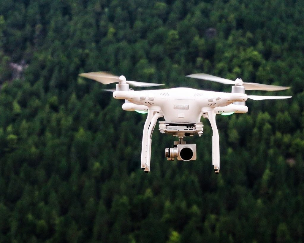
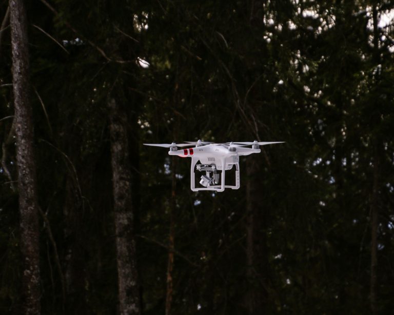
Unmanned aerial vehicles (UAVs, also known as drones) have existed in some form or another for at least 150 years. Today, a typical non-military drone looks something like this:
Although frequently used for more playful endeavors, the aerial imagery collected by drones can be used to improve forest management, essentially helping land managers see the forest for the trees. Drones can be used while conducting stand inventories and to monitor forest health, manage for wildlife, and plan harvests.
Tips for Drone Users
NNRG Lead Forester Jaal Mann frequently uses drones to document projects in the forest. We asked Jaal for five tips for operating drones and capturing good footage (and he gave us six!).
- Third-party applications work with many drones (not the popular DJI Mavic Mini yet, but they say it’s coming soon), and allow you to program autonomous flights in order to get smooth video coverage in straight lines over a property. You can also use third-party apps to program flights that take photos on an overlapping grid to create your own orthophotos!
- Always try to fly from a high point – if too many trees, or especially a hill, are between you and the drone you will lose connectivity. Also, legally you’re required to maintain line-of-sight on the drone.
- Be careful on windy days. If you’re concerned about the wind, make sure you fly upwind first otherwise you might find yourself downwind of your landing point without enough battery to return.
- Set your return-to-home height above the height of the tallest trees. That way, if the drone triggers an automatic return to home due to lost connection or low battery, it will rise above the trees before doing so. However, keep in mind that it won’t account for changes in elevation when it does this, so on a hilly site where you’re at the bottom of a hill it could still hit a tree.
- The elevation the drone’s display shows is elevation above the takeoff point. This means that if you start on a ridge and fly over a 200′ deep valley, your drone might be 600′ above the valley floor (and violating the FAA’s 400′ maximum height rule) even though it says 400′ on your display.
- Be sure to follow FAA guidelines and restrictions, and get a Part 107 license if you will be using your footage for any commercial purposes.
Drone usage is strictly regulated by the FAA. Before purchasing or using a drone, landowners should educate themselves on the rules to which drone pilots must adhere in order operate a drone safely. Regulations are different for commercial or recreational drone use.
Drone Resources
- Unmanned Aircraft Systems – The FAA’s homepage listing drone rules & regulations.
- Unmanned Aerial Vehicles (Drones): How they operate and their potential for improving your forest and rangeland management – A PDF publication by OSU Extension.
- Drones on smaller acreage woodlands – TreeTopics blog post from OSU Extension Forestry.
Lidar
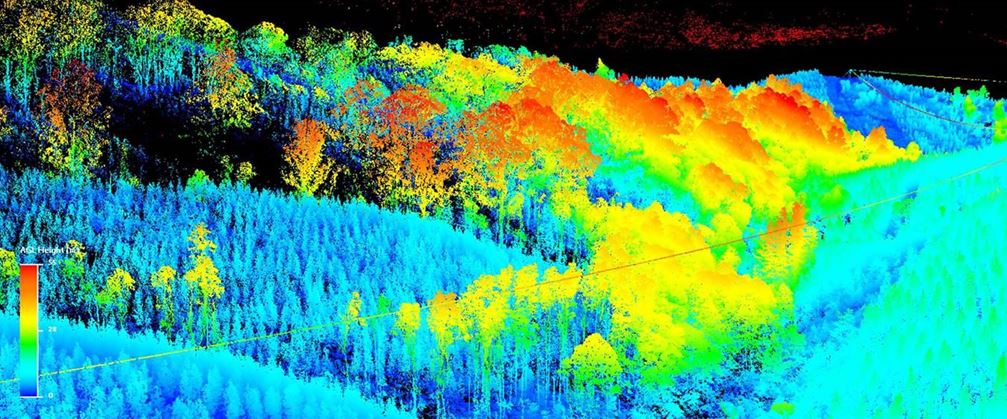
Lidar (also capitalized LiDAR) stands for Light Detection And Ranging. Lidar works a lot like a echolocation in bats, only using light instead of sound. A lidar instrument (often attached to a plane or mounted to something on the ground) fires rapid pulses of laser light at a surface and measures the amount of time it takes for each pulse of light to return to the instrument. That measurement translated into a location in space (height above sea level, GPS coordinates).
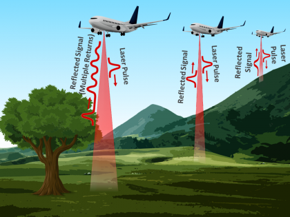
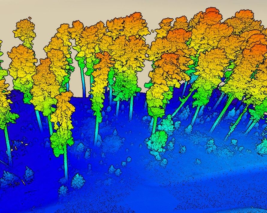
A lidar-equipped plane that flies over a forest creates a picture of the forest surface below from the laser pulses that hit the tops of the trees. This is called a Digital Surface Model. It can also create a picture of the terrain below any tree canopy, from laser pulses that make it through gaps in the trees and leaves. This is called a Digital Terrain model. “Terrain features that might be difficult to notice on the ground, either because of their large scale or thick vegetation, are really easy to see on lidar maps,” says Jaal.”What’s really helpful for forestry is that you can also subtract the surface terrain data from the canopy data, which essentially gives you only the trees. Using that, you can create maps showing how tree height varies across a landscape, and even count individual trees in some cases.”
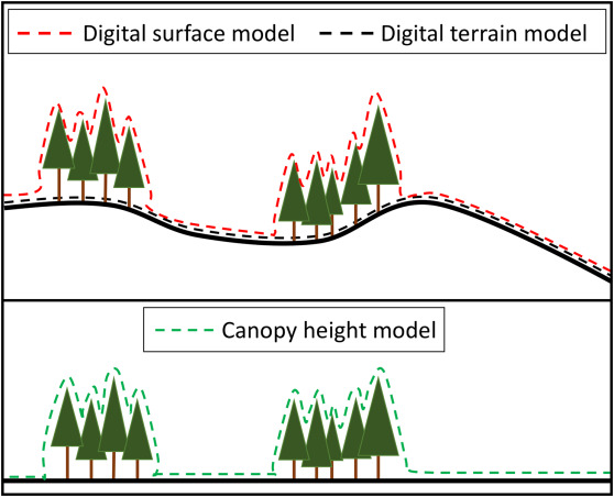

“Lidar datasets are also used to quickly calculate slope, so a land manager can get a simple representation of which areas of a property might be steep enough to be potentially unstable or require a different type of equipment for harvest.”
Lidar Resources
- Washington DNR Lidar portal – Free, publicly-available lidar data is available for many parts of Washington.
- Oregon Lidar – Lidar topographic data for many parts of Oregon.
Leave a Reply