
Mapping Tools for Forest Landowners
When NNRG foresters prepare for a site visit with a forest owner or begin drafting a forest management plan, one of the first steps they’ll take is to prepare a suite of maps that provide critical information about the characteristics of a forest. Although our forestry team includes professional cartographers familiar with Geographic Information Systems (GIS), a number of mapping tools and tech are accessible to the layperson and come at little to no cost.
Assembling a suite of maps for your forest
Even without a sophisticated GIS department, you can create or find a wide array of maps that provide very useful information about the natural resources on your land. These maps will articulate the topography of the land; identify the potential for streams to support fish, or whether streams are perennial or seasonal; express patterns of vegetation and forest cover; describe soil composition, productivity, and their ability to retain moisture; and reveal the history of land use. The chart below lists the types of maps and map data that are available online, as well as where you can find them on the web.
| Type of map | Online sources | Information provided | Notes |
|---|---|---|---|
| Aerial photo (recent or historical) | Google Earth County Assessor (WA) County Assessor (OR) WA DNR ODF | Current and historic land use, vegetative cover. | WA DNR and ODF only provide current aerial photos. |
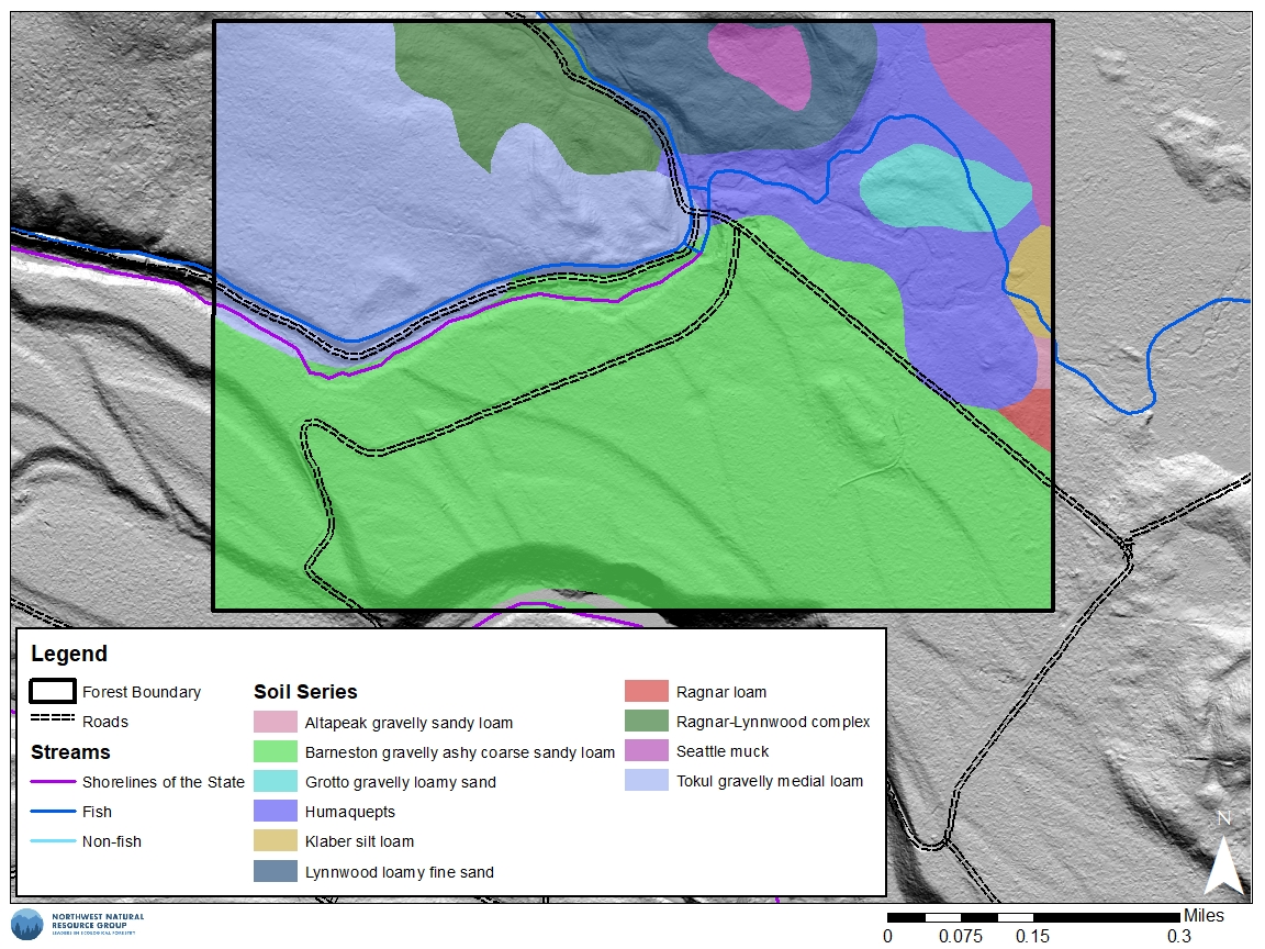
| Soil types | Google Earth NRCS Web Soil Survey | Soil types and descriptions based on NRCS soils data. | To generate a soil type map in Google Earth you must first download an extension from the NRCS’s website. |
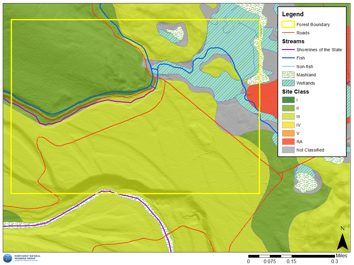
| Soil site class | WA DNR | Soil productivity on a I – V ranking from most to least productive. | This is a very simple ranking of soil productivity. |
| Soil site index | NRCS Web Soil Survey | Soil productivity based on average tree height over 50 or 100 year timeframes. | This is a more accurate estimate of soil productivity, and can be used to determine the volume of tree growth over time. |
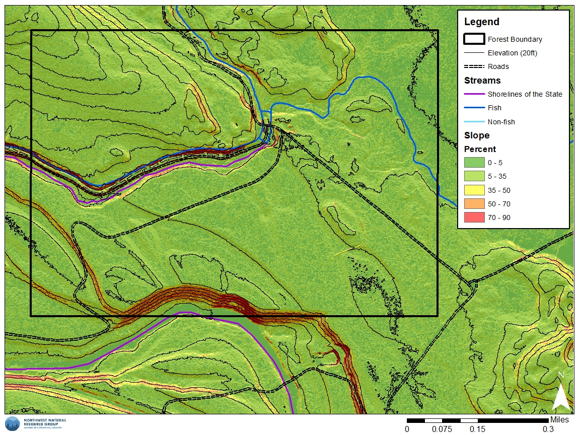
| Steep and unstable slopes | WA DNR ODF | Presence of potentially unstable slopes. | Forest practices may require special permission on steep or potentially unstable slopes. |
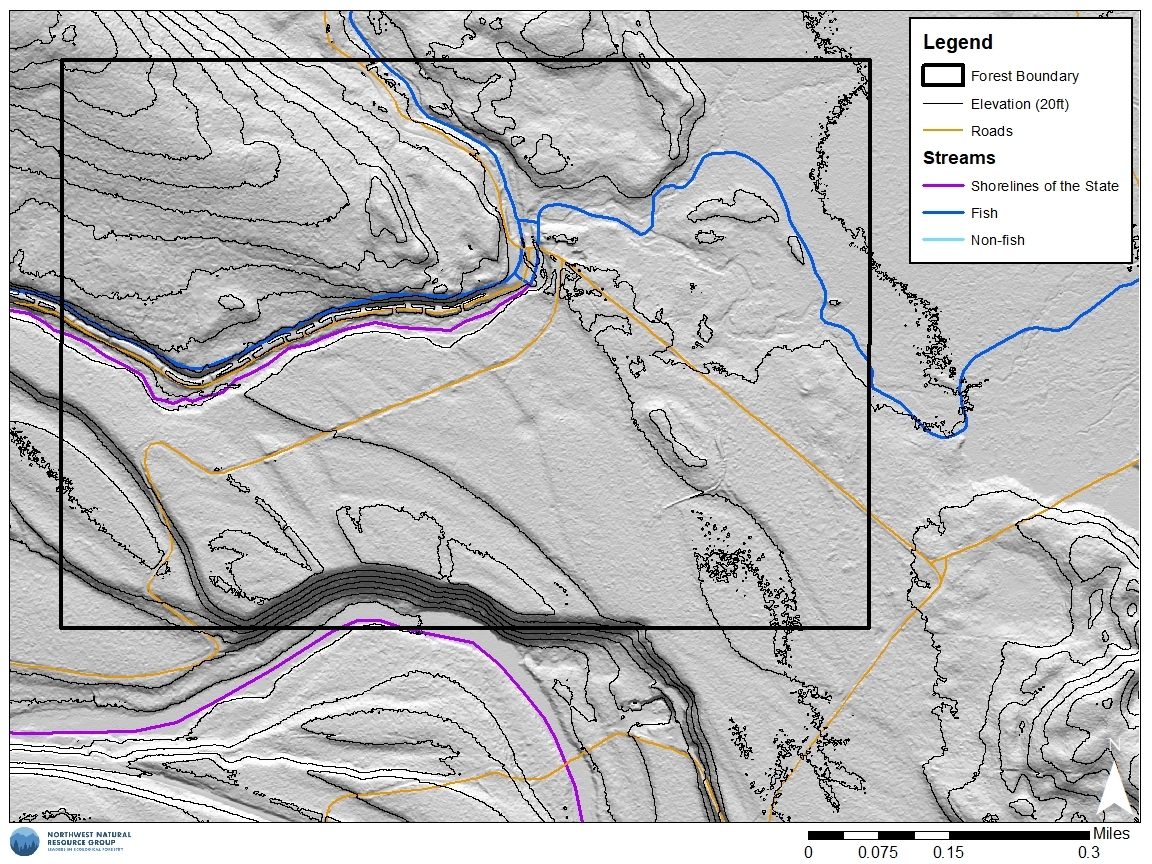
| Hydrology (streams and wetlands) | Google Earth NRCS Web Soil Survey County Assessor (WA) County Assessor (OR) WA DNR ODF | Rivers, streams, lakes, wetlands, and fish use. | WA DNR and ODF hydrology maps also identify if a stream is fish bearing. These maps are frequently erroneous and should be ground-truthed. |
| Topography | Google Earth NRCS Web Soil Survey County Assessor (WA) County Assessor (OR) WA DNR ODF | Contours of mountains, hills, ridges, valleys, lakes, and rivers. | To generate topo maps in Google Earth you must first download an extension from the USGS website. |
| Hillshade/terrain | County Assessor (WA) County Assessor (OR) WA DNR ODF | Hillshade/terrain maps provide highly detailed imagery of minute topography. | This maps can be very useful for identifying old road grades and landscape features that are not visible on either aerial or conventional topographic maps. |
Drawing Boundaries, Roads, and Trails Using Google Earth
Google Earth is an all around great tool for generating aerial photos, several resource maps, and recording useful monitoring information. Google Earth uses recent satellite imagery to produce an aerial view of the land, and also has an archive of historic imagery.
Once you’ve found the location of your land, Google Earth has a suite of mapping tools that, among many other functions, allow you to draw polygons to identify property and forest boundaries, as well as lines to identify roads and trails. The mapping tools also calculate area and distance. Google Earth does not include property parcel data, so you will need to estimate the location of parcel boundaries using another map as reference. Using the line tool, you can also either trace visible roads and trails, or add them to the best of your knowledge.
Click here for a tutorial on how to create a map on Google Earth
Avenza Maps
One of the most useful tools for landowners interested in monitoring and mapping their forests is, of course, the smartphone. Numerous free apps enable you to download aerial photos, topographic maps, soils data, geo-referenced PDF maps, and other resources that will aid you in navigating across a property and collecting information. Some common apps as of this writing include Avenza, Gaia GPS, Guru Maps, and OnX.
NNRG foresters mostly use Avenza Maps. The Avenza app uses your smartphone’s built-in GPS to locate you on a map even when you don’t have cell or internet service.
Interested in learning more about how to use Avenza? Come to NNRG’s upcoming Fireside Chat on Avenza mapping!
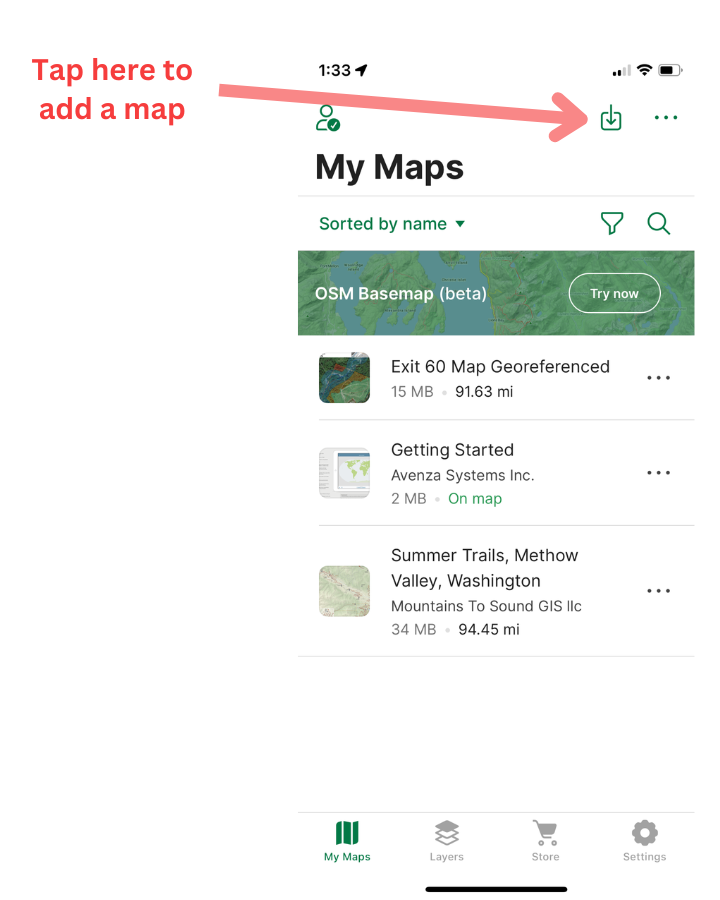
There are basically two ways to get maps in the app: import your own or use Avenza’s maps, some of which are free and some which can be purchased in the Avenza store. The basemap you’ll see when you first install Avenza shows a basic set of features including streets, larger water bodies, some contour lines, and some forest cover. Other maps, including maps specific to certain areas, can be found in the Avenza Maps store in the app.
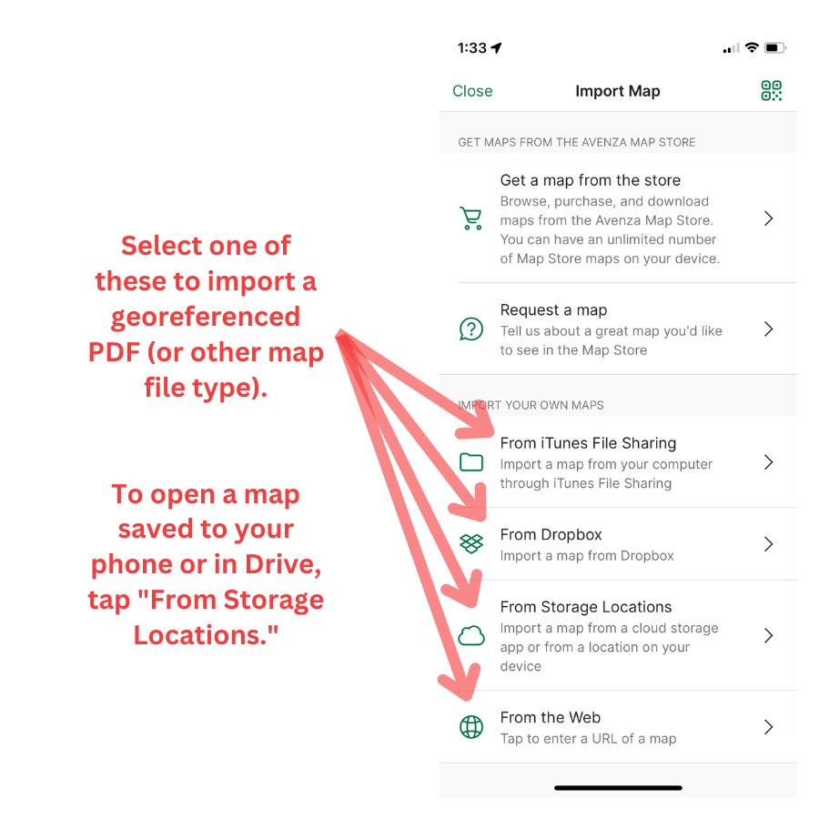
You can also import maps into Avenza. Avenza accepts a lot of file types (SHP, TIFF, KMZ, and GPX), but most landowners will be dealing with georeferenced PDFs. Many forest management plans, including those that NNRG prepares, include a set of georeferenced PDF maps. These are maps of a property that contain actual GPS coordinates digitally linked to points on the map. When you import a georeferenced PDF map of your forest into Avenza, you’ll be able to see your location on the map you imported. You can then create additional features like trails or location markers on that map.
There are a number of ways to import a PDF map into Avenza (we will be going over a few of these techniques at our upcoming Fireside Chat):
- If you have email on your phone, you can email yourself the map from your computer, then open and save the map on your phone.
- If you have a Google Drive account and you have the Google Drive app installed on your phone, you can save the map in your Drive and then open it in Drive through Avenza.
- If you have a Dropbox account you can save the map in Dropbox and then open it in Dropbox through Avenza.
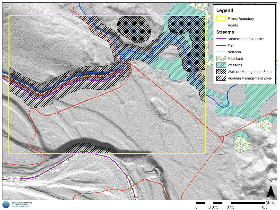
Maps included in a forest management plan prepared by NNRG
For a fee ($200-$350), NNRG can produce a suite of maps for a forest landowner in Washington and Oregon. The standard suite of georeferenced PDF maps included in a forest management plan prepared by an NNRG forester are:
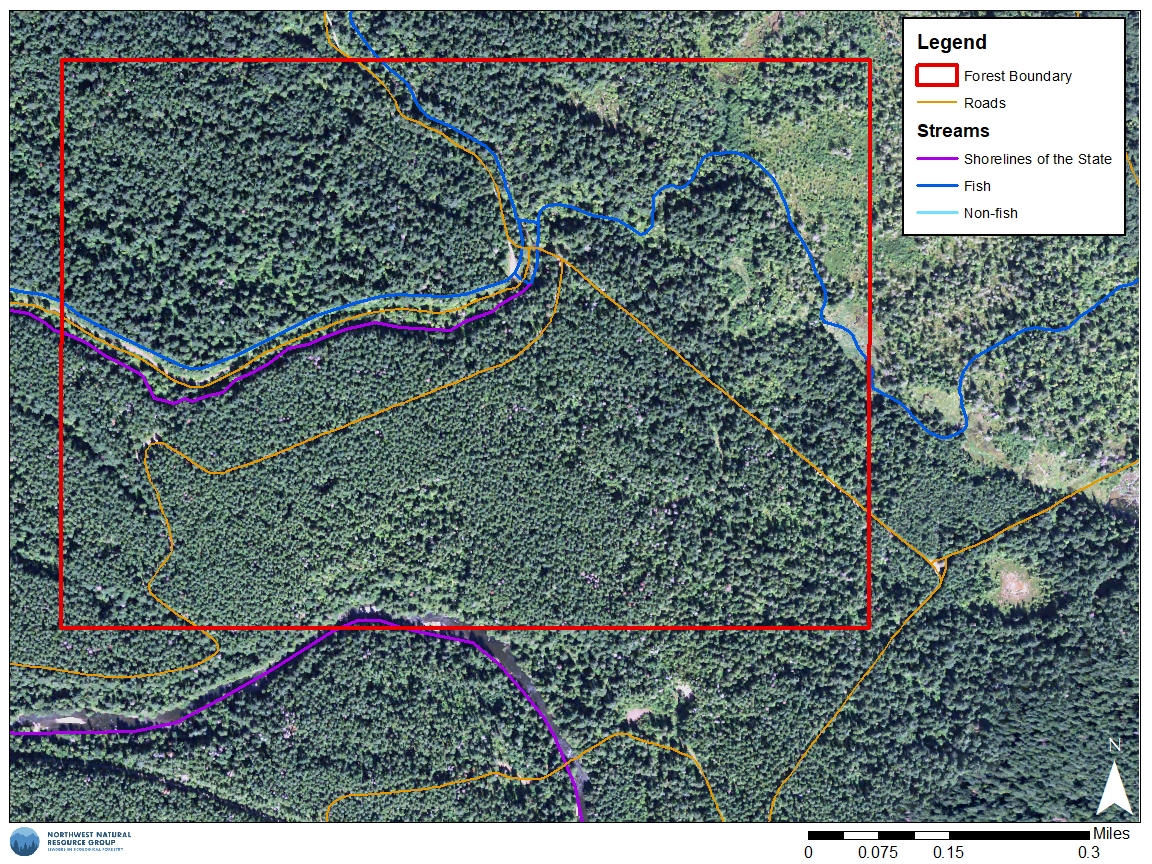
- Aerial Map
- Topographic/Hillshade Map
- Slope
- Hydrology
- Site Class
- Soils
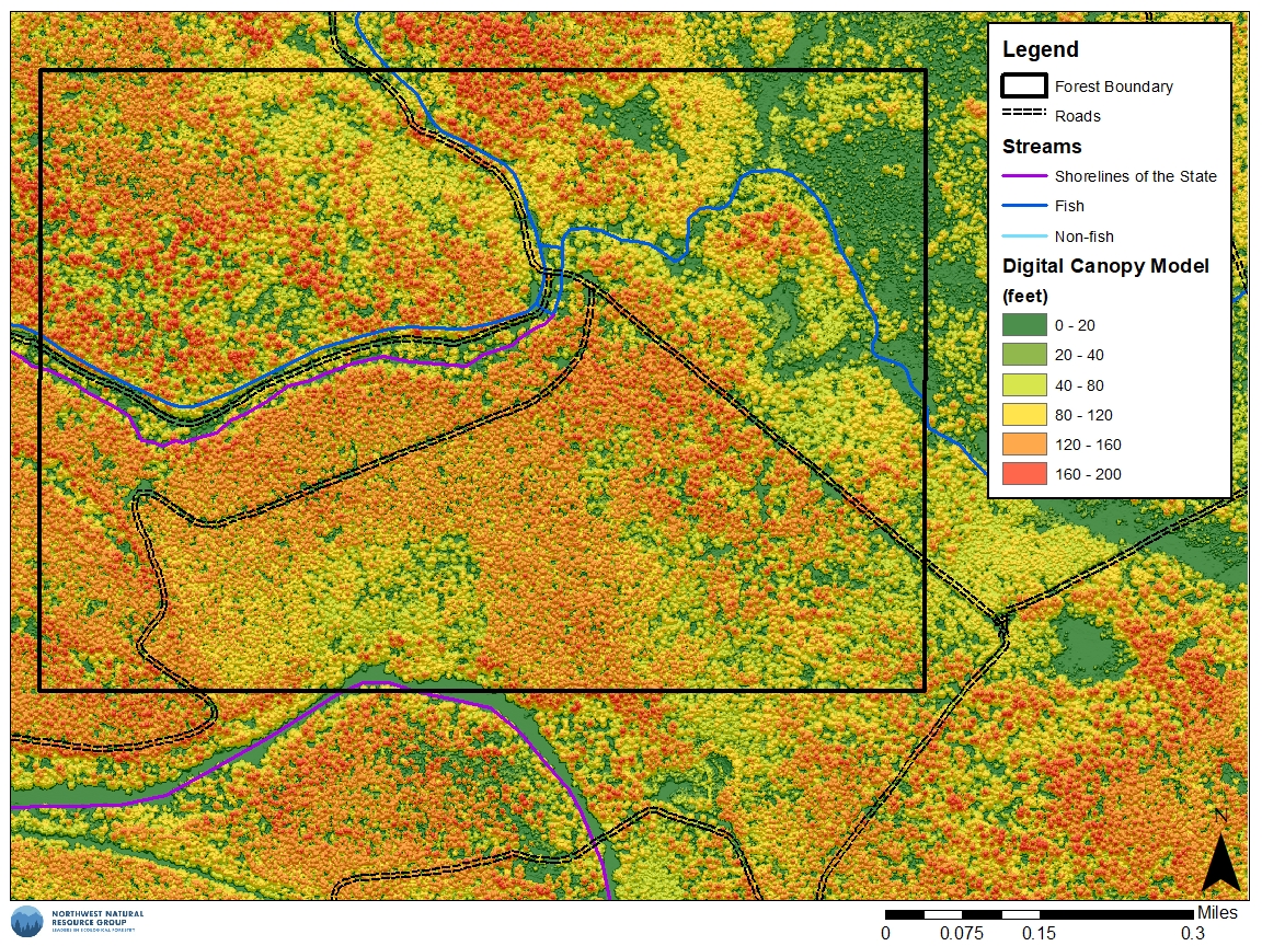
- Canopy Map
- Forest Management Units
- (CAP/CPA Costshare Activity Map)
If you are working with NNRG to plan a commercial or pre-commercial thinning, additional maps would show the boundaries of different types of harvest activities. Below are examples of what these types of maps look like
This article was adapted from NNRG’s forthcoming book, A Forest of Your Own: The Pacific Northwest Handbook of Ecological Forestry, to be published in spring 2024 by Mountaineers Books.
Leave a Reply